Home/About & Partners

A cross-border answer to a cross-border fire.

Karst Firewall 5.0 is an innovative ecosystem-based plan to adapt to climate change in the Karst — promoting fire-resilient forestry supported by an Industry 5.0 approach, co-funded by the Interreg VI-A Italy–Slovenia Programme.

28
Months
6
Partners
1.06M
Budget
849K
ERDF
90%
Progress
2
Countries

15 April 2024 → 14 August 2026 · Policy Objective 2 (a greener Europe) · Specific Objective 4 — climate adaptation & disaster-risk prevention · Project ITA-SI0600146

The project

Wildfires, and their governance.

The Karst Firewall 5.0 project addresses two linked challenges in the programme area: wildfires and their governance. It develops innovative action plans to preserve the health of the Karst region and maximise its resilience.

Wildfires here are primarily driven by ongoing climate change, and current firefighting strategies are becoming less effective. Because the study area straddles the Italy–Slovenia border, cross-border cooperation is essential — a need made urgent by the significant wildfire event of summer 2022. The project integrates socio-ecological and socio-technological systems, broadening dialogue among the responders, sectors and communities affected by fire.

OBJECTIVE 01

Develop an effective cross-border mechanism for wildfire prevention and management.

OBJECTIVE 02

Develop and use innovative digital systems — drones, satellite imagery, predictive AI and "electronic noses" — to monitor risk and support first responders.

OBJECTIVE 03

Promote cross-border adoption of these technologies for more effective prevention systems and management protocols, in line with Industry 5.0.

5.0
Industry · Society
Why “5.0”

A 5.0 approach: technology beside people and nature

The “5.0” in Karst Firewall is deliberate. Where Industry 4.0 automates, Industry 5.0 and Society 5.0 put people and the planet back at the centre: technology that supports and empowers human work rather than replacing it. Here that means tools which quietly strengthen everyday wildfire prevention — sensors, AI and a digital twin woven together with the Karst landscape and the communities who care for it, in a way that stays simple, sustainable and human.

The partnership

Six partners, two countries

IUAV
Lead partner

Università IUAV di Venezia

Italy · project coordination

Project coordinator and scientific research. Project PM Massimiliano Granceri Bradaschia, PhD Arch. Pian.

Infordata
Project partner

Infordata Sistemi Srl SB

Italy · digital platform

Digitalisation and AI models — builds the platform and the fire-intelligence models.

ZRC SAZU
Project partner

ZRC SAZU

Slovenia · research (Academy of Sciences)

Scientific research and field operations with drones and Earth observation.

Duino Aurisina – Devin Nabrežina
Pilot municipality

Comune di Duino Aurisina – Občina Devin Nabrežina

Italy · cross-border municipality

Pilot site and use case — also procured equipment and ran on-the-ground wildfire interventions.

Miren-Kostanjevica
Pilot municipality

Občina Miren-Kostanjevica

Slovenia · municipality

Pilot site and use case — also procured equipment and ran on-the-ground wildfire interventions.

KID PiNA
Project partner

KID PiNA — Associazione Culturale ed Educativa

Slovenia · community & education

Community engagement, education and public outreach.

Associated partners

Inside the partnership

What each partner brings

Six partners, each carrying a distinct part of the work — from the science and the platform to the budgets and the bricks on the ground.

Lead partner · coordinator & scientific lead

Università IUAV di Venezia

Beyond coordinating the consortium, IUAV authored the project's core science: the cross-border climate-change assessment, the wildfire hazard & vulnerability maps, the prevention abaco, and the participatory laboratories that tested it with the people who fight fire.

5 foundational studies authored or co-authored
Research & results →
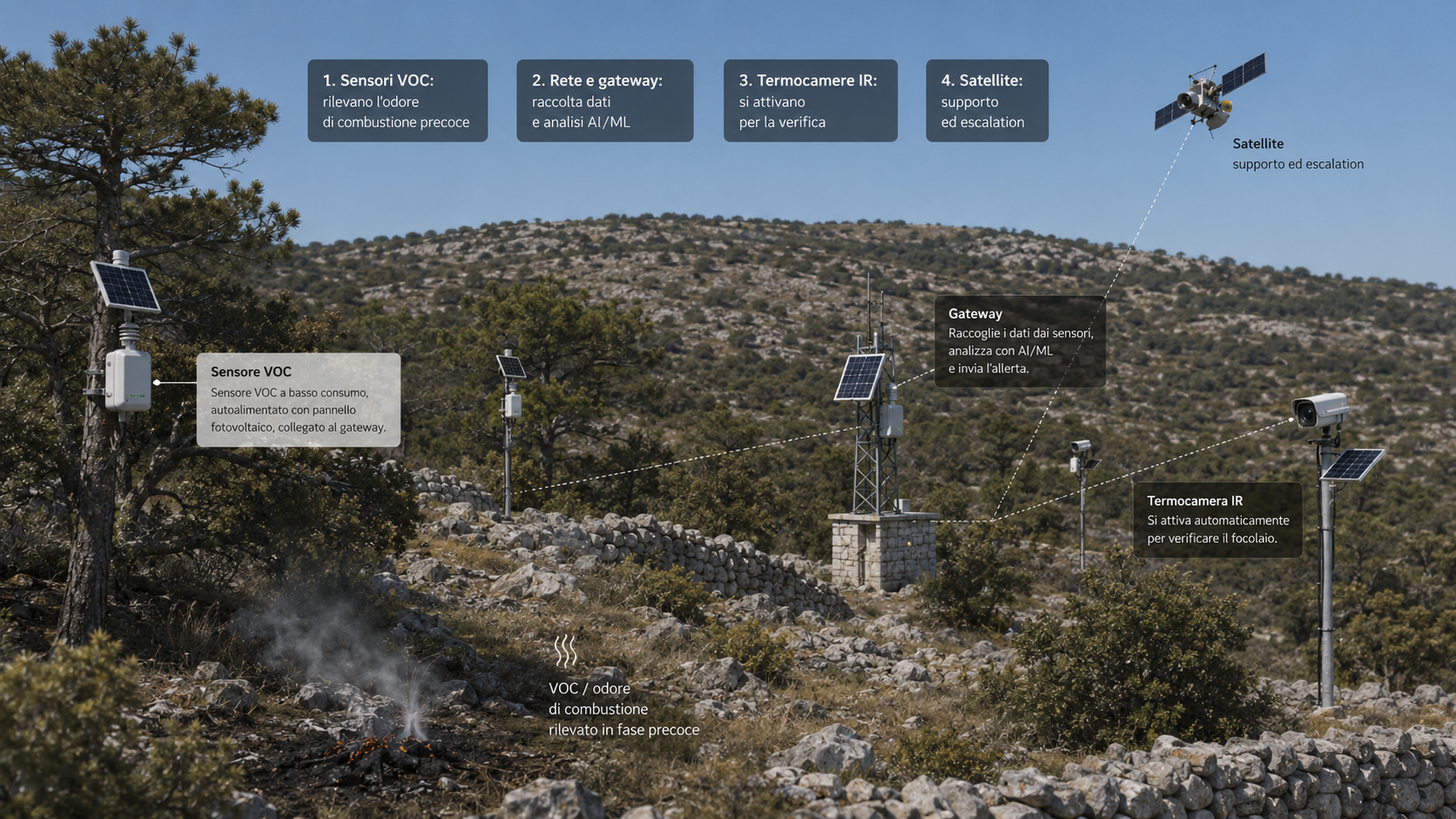
Project partner · the digital backbone

Infordata Sistemi Srl SB

A Società Benefit that designed and built the whole platform and the fire-intelligence behind it: the Karst Fire Weather Index, a machine-learning ignition model that lifts wildfire detection from a 29% baseline to 77.5%, a daily risk map over ~40,000 grid points, and cross-border alerting by email, SMS and WhatsApp.

AUC 0.934 ignition model · 4 alert channels
How the KFWI works →
Project partner · science & Earth-observation engine

ZRC SAZU

The Slovenian Academy's research centre co-authored the climate and hazard/vulnerability science, built the cross-border remote-sensing burned-area database (171 historical fires from 30 years of satellite imagery), flew four seasons of multispectral drone surveys, and led the Slovenian pilot in Miren-Kostanjevica.

171 burned-area maps · 4-season drone monitoring
Eyes on the Karst →
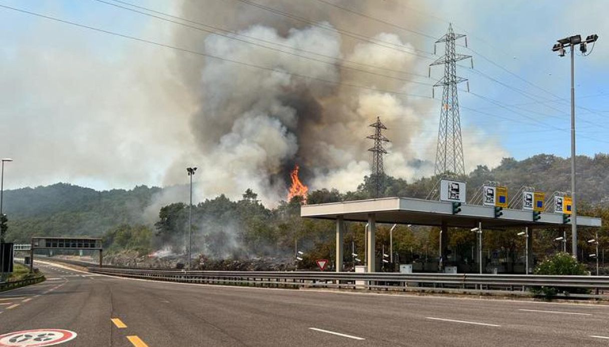
Pilot municipality · investments on the ground (IT)

Comune di Duino Aurisina – Občina Devin Nabrežina

Turned the plan into ground action after the 2022 fire: 9 hectares of selective black-pine clearing (~270 m³ of dead wood removed), procurement of electronic-nose sensors and drones that feed the platform, and reactivation of grazing to keep the Karst heathland open — while stewarding the 107-hectare Falesie di Duino reserve.

9 ha restored · 107 ha reserve managed
Pilot sites →
Pilot municipality · investments on the ground (SI)

Občina Miren-Kostanjevica

Ground zero of the 2022 mega-fire (~1,000 ha burned in the municipality alone), Miren-Kostanjevica co-financed three pilot actions — preventive grazing on the burn scar, dry-stone-wall restoration that doubles as firebreak and heritage, and dolina mosaic restoration — and has committed to scaling them past 2026.

3 pilot actions · 22-year land-use evidence base
Pilot sites →
Project partner · community & education

KID PiNA

PiNA designed and facilitated the participatory laboratories that brought about 60 farmers, foresters, firefighters and officials to the table, turning lived local knowledge into 29 municipal and 8 national prevention measures, and built gamified fire-awareness learning for young people.

~60 stakeholders engaged · 37 measures co-produced
Prevention →
The Karst Fire Weather Index

An index that actually sees the Karst.

Generic European fire-danger maps treat the Karst like anywhere else — and miss almost all of its fires. The KFWI pairs Karst-calibrated FWI severity with a machine-learning ignition model to fix that.

97.3%

of Karst fires occur below Europe's generic "High" fire-danger threshold — invisible to a one-size-fits-all index.

77.5%

fire detection with the KFWI, versus a 29% baseline using FWI alone.

0.934

AUC of the Random Forest ignition model behind the index.

Fire-weather severity

Copernicus-backed FWI forecasts establish daily fire-weather severity across the AOI.

ML ignition model

A Random Forest model estimates ignition probability from hotspot density, infrastructure distance and seasonally-corrected sampling.

Karst calibration

Severity and ignition are fused and locally calibrated to Karst fuels, terrain and climate.

Operational risk

The result drives the daily risk map, nowcasts and intervention planning — at street level.

Early warning

An electronic nose that smells wildfire

Before a fire is hot enough for a thermal camera to see, it already smells. A cross-border network of low-cost electronic-nose sensors — mounted on trees in the most vulnerable zones — detects the volatile organic compounds (VOCs) of early combustion and raises the alarm in real time, often before any flame or smoke plume is visible.

A field electronic-nose (VOC) sensor node on the Karst

✦ Illustrative image generated with AI.

VOC

Smell, not heat

Each node continuously samples the air for the volatile organic compounds released by smouldering vegetation — the chemical fingerprint of a fire, minutes to hours before flames or a thermal signature appear.

ML

Trained on wildfire

An embedded machine-learning model is trained to tell the specific smell of a Karst wildfire from ordinary background air, so the network triggers a real-time alarm while keeping false positives low.

LoRaWAN

Autonomous in the field

Nodes communicate over long-range, low-power LoRaWAN and run on a small solar panel and battery — no mains power, no cabling. Each one also logs temperature, humidity, air pressure and VOC levels.

TWIN

Sharper simulations

Beyond the instant alarm, the live sensor stream feeds the digital twin: real micro-climate and early-detection data make the fire-spread simulator more precise.

Project coordination: Università IUAV di Venezia, Santa Croce 191, 30135 Venezia — Francesco Musco · karstfirewall@iuav.it. Digital platform: Infordata Sistemi Srl Società Benefit, Strada per Vienna 55/1, 34151 Trieste (TS), Italy.

Karst Firewall 5.0 — the cross-border wildfire digital twin — was designed and developed by Infordata Sistemi Srl Società Benefit. Its alert and monitoring features are offered free of charge to the public; access to the reserved area with the standard functions is also free for academia, researchers, students, public administration and NGOs. Advanced functions and dedicated support are available commercially, including for businesses — sales@infordata.it.

Licensing — Karst Firewall 5.0 follows an open-core model: the community platform and the project knowledge are openly licensed, while the advanced modules and the hosted service are commercial. Three layers, three licences:

Core community platform
EUPL-1.2-or-later — the platform source code is released as open source under a copyleft licence drafted by the European Commission and well suited to EU public projects.
Docs, methodology & datasets
CC BY 4.0 — the documentation, the KFWI methodology and the published datasets are free to share and adapt, with attribution.
Advanced modules & SaaS
Proprietary — the advanced / enterprise modules and the hosted (SaaS) service are offered under a separate commercial licence.